

Computational Geosciences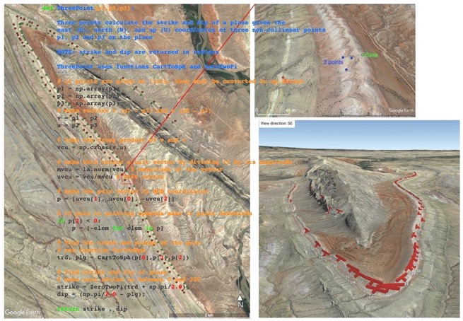
Strike and dips in the Sheep Mountain anticline (Wyoming) from Google Earth data and a Python script!
This page contains links to several Python resources for computational geosciences that I have developed with students and colleagues. These are available in my GitHub repository. I am grateful to the Faculty of Sciences and Technology (TEKNAT) at the University of Stavanger (UiS) for supporting the students' projects.
Online computational geosciences resource: As part of an educational project funded by TEKNAT (UiS), we developed a Python-based online resource in Computational Geosciences. This resource is available here, and it consists of a book (pdf) and code (functions and notebooks). Feel free to use this material for teaching and research. The people who were involved in this project are the students Angela Hoch (Computational Engineering), Adham Amer (Offshore Engineering), Vania Mansoor (Petroleum Geosciences), and Linda Olsen (Petroleum Geosciences); postdoc David Oakley; and faculty Nestor Cardozo (Structural Geology), Lisa Watson (GIS), Wiktor Weibull (Geophysics), and Knut Giljarhus (Fluid mechanics).
Meaningful programming modules on YouTube: As part of an educational project funded by TEKNAT (UiS), the students developed 12 videos or modules to learn Python. The videos are available on YouTube playlists in both English and Norwegian. The students who participated in this project are Solmøy Austbø, Alexander Djario Raffn, Artem Kornienko, Syed Nazim, and Tongtong Yu, all from the Institute of Energy Resources (IER), except Tongtong who was at the Institute of Energy and Petroleum (IEP). I supervised this project together with Erlend Tøssebro at Data and Electrical Engineering (IDE).
Python for Geosciences: In 2022 and 2023, I taught a Python and machine learning course for geoscientists, together with Anita Torabi and Behzad Alaei at the University of Oslo. I taught the first week on Python, and Anita and Behzad taught the machine learning part. The first week of the course is available here.
Python for subsurface applications: This is a one-week course I taught at ConocoPhillips Stavanger in May 2025. I revised the content to include public datasets. The course is available here.
Structural Geology: A collection of Python Jupyter Notebooks for Structural Geology, and especially for my Bachelor course on the subject. The notebooks are available here. The lectures from the course are available on this YouTube playlist.
Geologic maps to 3D models: In an attempt to better learn and teach geological map interpretation, I have converted classical maps from Bennison et al. (2011) to 3D models using the Python geomodeling tool GemPy. The notebooks are available here.
Energy plots: You have probably watched the movies in my Energy Plots page. These are animations showing energy trends over time, and using data from the Statistical Review of World Energy. I automated the making of these movies with Python, and the material is available here.
Feedback:
I appreciate your comments and input. Please contact me.